Reality capture, compared
Matterport vs LiDAR: Which Reality-Capture Method Fits Your Project?
By the ScanningAndModeling team · Last updated July 9, 2026
Matterport is quick, simple, and pretty: a fast photographic replica of a space, accurate enough to locate things and remember what is behind the drywall later. Terrestrial LiDAR is measurement-grade, holding roughly 2 to 4 millimeter accuracy, and it is what design work runs on. And a third step sits behind both: the Revit model an architect designs in is drawn by hand from the scan data, separately, no matter which method captured it. Match the method to what the data has to do, and the choice is straightforward.
The short answer
Match the tool to what the file has to do after capture day. If the deliverable exists so people can see the building, remote walkthroughs, leasing tours, insurance records, a rough sense of where things sit, Matterport does the job for $350 to $2,000 in about half a day. If the deliverable exists so people can measure the building, renovation drawings, Revit models, MEP coordination, you need a terrestrial scanner holding ±2-4 mm, and a small commercial capture runs $3,000 to $8,000 over 1 to 2 days of fieldwork plus processing.
Both get sold under the word "scan." They are not interchangeable, and the price gap between them is not padding. It is the cost of accuracy your downstream workflow either needs or does not. One more thing neither method includes: the drawn Revit or CAD model. That is a separate step built from the scan data by a modeling team, covered in does a 3D scan include the model. The rest of this guide shows exactly where the lines sit, with the numbers side by side.
Why the comparison confuses buyers
Matterport markets the Pro3 as a LiDAR camera. The claim is technically true. The Pro3 carries a LiDAR sensor, and the datasheet says so. The same datasheet puts its accuracy at roughly 20 mm at 10 m. A Trimble X12 holds ±2 mm at 20 m. The Leica RTC360 and FARO Focus class holds ±2-4 mm at 10-20 m. Same word on the spec sheet, roughly a tenfold gap in what the data supports.
That one shared word puts a $350 capture and an $8,000 capture under the same label, and buyers pay for the confusion. The pattern repeats across BIM and surveying forums: a buyer commissions a Matterport scan, hands the file to a design team, extracts measurements, and the measurements do not hold. As one BIM professional put it plainly, Matterport LiDAR and photogrammetry do not hit construction tolerances, and are not recommended for construction drawings. The capture was not defective. It was the wrong instrument for the job it was given.
What Matterport actually delivers
A Matterport capture produces a photographic virtual walkthrough: pan through every room, jump between floors, view the building as a dollhouse model, and share it all with a link. Capture takes about half a day and runs $350 to $2,000. You can also order approximate floor plans generated from the capture. The capture leans on photogrammetry first, stitching photographs into a walkable replica, with the LiDAR sensor supporting it.
Within its lane, it is genuinely excellent. This is why custom home builders buy it: a builder captures the framing, plumbing, and wiring before the drywall closes, and months later has a photographic record of exactly what is behind the wall. Turnaround is fast, often 24 to 48 hours. It is the right tool for real estate marketing, leasing tours, insurance documentation, remote stakeholder walkthroughs, and locating things after the fact. For those jobs the photographic detail matters more than millimeter geometry, and nothing at this price point communicates a space better. Here is a Matterport walkthrough we captured. Open it. Walk it. That experience is the product.
| Matterport is strong for | Matterport is the wrong tool for |
|---|---|
| Walkable visual replicas anyone opens in a browser | Construction-tolerance measurements for design |
| Locating what is behind the drywall later (builders, pre-close capture) | Revit models and MEP coordination that need ±2-4 mm |
| Fast turnaround, often 24-48 hours | As-built drawings held to a written accuracy spec |
| Real estate, leasing, insurance, remote walkthroughs | Any deliverable an engineer stamps or designs against |
What terrestrial LiDAR actually delivers
A terrestrial scanner sits on a tripod and measures millions of individual points, each with X, Y, Z coordinates, from every setup position. The positions get registered into a single dataset called a point cloud, delivered as an E57 or RCP file. Our guide to what a point cloud is covers the format in plain English. The Leica RTC360 and FARO Focus class holds ±2-4 mm at 10-20 m. The Trimble X12 holds ±2 mm at 20 m. Mobile SLAM scanners like the NavVis VLX and Leica BLK2GO sit between the two worlds at 1-3 cm. This is the accuracy architects and engineers work from, and it is why they specify it.
From that point cloud come the deliverables design teams work in: 2D as-built drawings and Revit models at a specified Level of Development, the process explained in our scan-to-BIM explainer. Note the sequence: the point cloud is the measurement, and the drawn model is a third, separate step built from it by a modeling team. The scanner does not draw the model. People do. A small commercial building (5,000 to 15,000 sq ft), point cloud only, runs $3,000 to $8,000 over 1 to 2 days of field time plus processing. These as-built models we delivered show what the finished product looks like.
| Terrestrial LiDAR is strong for | Terrestrial LiDAR is overkill for |
|---|---|
| Measurement-grade point clouds at ±2-4 mm | A marketing walkthrough where nobody measures |
| Renovation design, Revit modeling, as-built drawings | A quick visual record for remote stakeholders |
| MEP coordination and clash detection | Insurance documentation of general condition |
| Any file a design team measures and builds from | Jobs where a centimeter of tolerance is fine and speed wins |
Accuracy, side by side
This table is the whole argument in six rows. Every figure is the manufacturer's stated spec or the accepted class figure for that capture type.
| Capture system | Class | Stated accuracy | Built for |
|---|---|---|---|
| Trimble X12 | Survey-grade terrestrial LiDAR | ±2 mm at 20 m | Design, construction, engineering |
| Leica RTC360 | Survey-grade terrestrial LiDAR | ±2-4 mm at 10-20 m | Design, construction, engineering |
| FARO Focus | Survey-grade terrestrial LiDAR | ±2-4 mm at 10-20 m | Design, construction, engineering |
| NavVis VLX, Leica BLK2GO, FARO Orbis | Mobile SLAM LiDAR | 1-3 cm typical | Fast capture of large areas |
| Matterport Pro3 | Visual-first LiDAR camera | ~20 mm at 10 m | Walkthroughs, visual documentation |
| Matterport Pro2, Insta360, Ricoh Theta | Photo-based 360° capture | Below Pro3 | Photo tours |
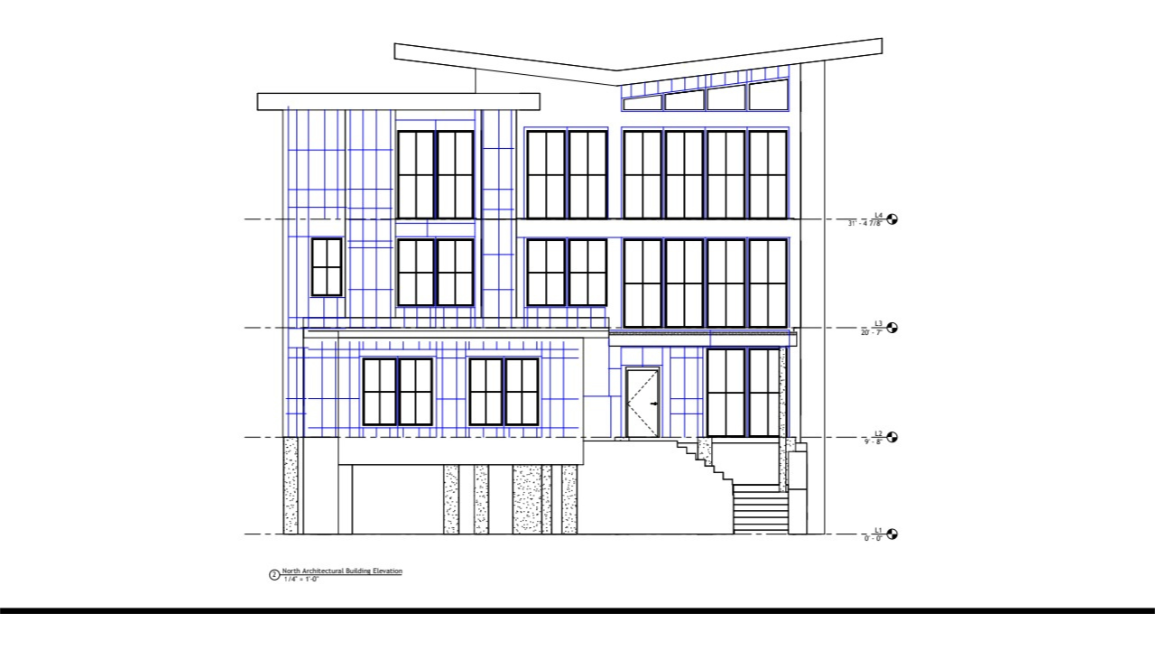
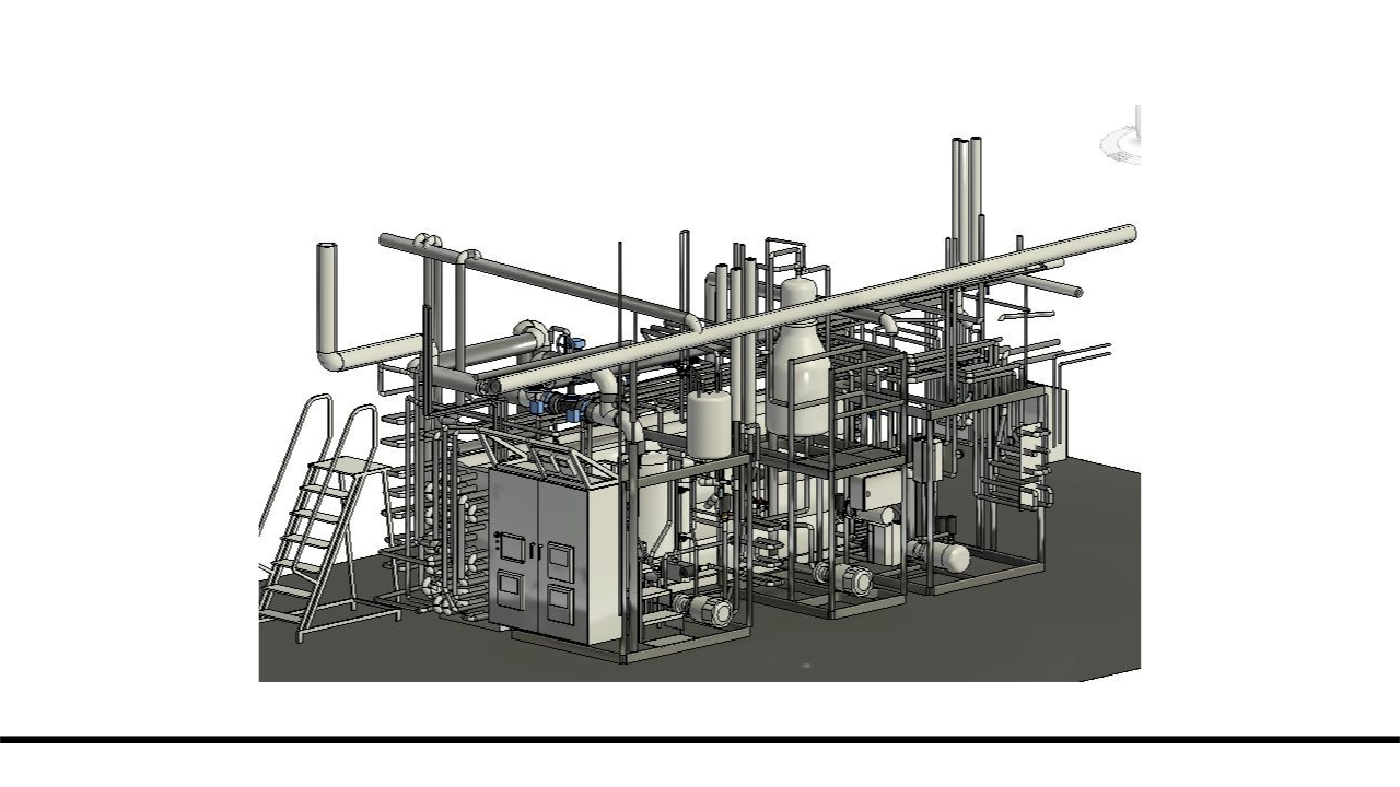
Seeing the difference beats reading about it. These are two measurement-grade deliverables the LiDAR path produces: a dimensioned 2D as-built elevation, and a 3D model of the mechanical systems. This is the engineering output a Matterport walkthrough cannot give you.
Cost: per capture and per deliverable
Per capture, Matterport wins on price every time. Per deliverable, the math changes, and per deliverable is the only comparison that matters, because nobody buys a scan for its own sake.
| Matterport capture | Terrestrial LiDAR | |
|---|---|---|
| Typical price | $350-$2,000 | $3,000-$8,000 (small commercial point cloud) |
| Field time | About half a day | 1-2 days plus processing |
| Accuracy | ~20 mm at 10 m | ±2-4 mm at 10-20 m |
| Primary deliverable | Virtual walkthrough, approximate floor plans | Registered point cloud (E57 / RCP) |
| Supports construction-grade as-builts and scan-to-BIM | No | Yes |
Here is the per-deliverable math. If the project needs a walkthrough, the $350 to $2,000 Matterport capture is the complete answer and the terrestrial scanner is wasted money. If the project needs construction-grade as-builts, the Matterport file does not support them, the building gets captured a second time with a terrestrial scanner, and the cheaper capture becomes an added cost instead of a saving. Full price ranges for every deliverable type, from tours to scan-to-BIM at $0.10 to $8.00+ per square foot, are in our guide to what 3D laser scanning costs in 2026.
When Matterport is enough
Matterport is the right spec, and the cheaper one, anywhere seeing beats measuring. Real estate listings and leasing tours, where the walkthrough is the sales asset. Insurance documentation, where a dated photographic record of condition is the point. Remote stakeholder walkthroughs, where an owner in another state needs to experience the space without flying in. Facility familiarization, where a maintenance or security team learns a building before working in it. In every one of those cases a survey-grade point cloud adds thousands of dollars and answers questions nobody asked. Buying more accuracy than the workflow uses is the quieter version of the same spec mistake, and a vendor who owns only terrestrial scanners will not talk you out of it.
When Matterport is the wrong tool
Three jobs recur in the forum complaint threads, and all three need terrestrial capture. As-built drawings: dimensions pulled from a ~20 mm dataset do not hold to construction tolerances, which is why the answer to "can I get as-builts from my Matterport" is approximate floor plans at best. Renovation design: architects model in Revit from registered point clouds, and a Pro3 capture cannot reliably support construction-grade modeling tolerances. MEP coordination: routing pipe and duct through an existing building against clash detection demands the ±2-4 mm class, full stop.
There is a network effect behind the mismatch. Matterport's partner network is hardware-tied and heavily weighted toward real estate, and it cannot fulfill survey-grade scan-to-BIM. A buyer who starts with a Matterport partner and later needs engineering data is starting the vendor search over from zero. Our reality capture buyer's guide maps all four capture methods to the deliverables they support, so you start the search once.
One project, both captures
The two methods combine well, and the combination is often the smart spec. Terrestrial LiDAR captures the geometry your architect and engineers need. Matterport captures the walkthrough your stakeholders, lenders, and facility teams want. Done on the same mobilization, one site visit produces both, and the mobilization cost gets paid once instead of twice.
A disclosure that doubles as a credential: this comparison comes from running both. We operate Matterport cameras and terrestrial scanners, and invoice for both. Most Matterport-vs-LiDAR articles are written by a vendor holding one of the two, which is why they end where the author's hardware ends. We have no reason to talk you out of either method. We have every reason to spec the right one, because the deliverable gets checked before you accept it.
The decision framework
Four rules settle almost every project. First: the file feeds design, construction, or engineering, so spec terrestrial LiDAR at ±2-4 mm and put the accuracy requirement in the contract using USIBD LOA v3.1 language. Second: the file exists for viewing, sharing, or documentation, so spec Matterport and keep the difference in your budget. Third: the project needs both measuring and seeing, so spec both on one mobilization. Fourth: you are not sure what the downstream workflow needs, so answer that question before any hardware question, because the deliverable determines the instrument, never the reverse. That fourth case is the one we built our intake around. Describe the project and what the data is for, and the method question resolves itself.
Questions buyers actually ask
Is Matterport LiDAR?
The Pro3 uses a LiDAR sensor, yes. But at roughly 20 mm accuracy it is not survey-grade LiDAR, and the two should not be quoted as equivalents.
Can I get as-built drawings from a Matterport scan?
You can get approximate floor plans. You cannot reliably get construction-grade as-builts; that requires ±2-4 mm terrestrial capture.
Which is cheaper, Matterport or terrestrial LiDAR?
Matterport, at $350-$2,000 per capture, beats terrestrial LiDAR at $3,000-$8,000 and up on price. Whether it is a better deal depends entirely on what the file needs to do downstream.
When is Matterport the right choice?
Real estate marketing, leasing tours, insurance documentation, remote stakeholder walkthroughs, and facility familiarization. Anywhere seeing beats measuring.
Can one project use both Matterport and terrestrial LiDAR?
Yes, and it is often the smart spec: terrestrial LiDAR for the geometry your architect needs, Matterport for the walkthrough your stakeholders want, captured on the same mobilization.
Does either method include the Revit model?
No. Both methods capture data. The Revit or CAD model is drawn from that data by a modeling team and is a separate service, priced on top of the scan. The full explanation is in does a 3D scan include the model.
Get the right capture method for your project
Tell us the building and what the data needs to do. We identify the deliverable your workflow actually needs, Matterport, terrestrial LiDAR, or both on one mobilization, then capture it. A Matterport capture runs $350 to $2,000. A survey-grade point cloud for a small commercial building runs $3,000 to $8,000.
Get a quoteAbout the author
The ScanningAndModeling team writes these guides from the field: the people who scan, model, and deliver reality-capture work across the country every week. Plain-English answers with real numbers, so you can spec a project without guessing.